

Bayard’s Mount Fort (Bunker Hill)
Periods: Manhattan 1776 Also known as: Bayard’s Hill Redoubt, Fort Bunker Hill, Independent Battery, Bayard’s Mount, Bunker Hill Coordinates: 40.7190, -73.9970 (approx. summit) Modern location: Around Grand & Mulberry/Mott Streets, in today’s Little Italy — roughly the area bounded by Centre, Broome, Mott, and Grand Streets Elevation: ~110 ft (34 m) — the tallest hill in lower Manhattan before grading
Summary
Bayard’s Mount was the highest point in lower Manhattan, a cone-shaped hill rising about 110 feet just northeast of Collect Pond. In the spring of 1776 the Continental Army crowned it with a large heptagonal (seven-pointed star) earthwork redoubt — variously called the Bayard’s Hill Redoubt, Fort Bunker Hill, or the Independent Battery — the strongest inland work in the city’s Revolutionary War defenses. The hill was leveled between about 1802 and 1811, its earth used to fill the Collect Pond, and no trace remains today.
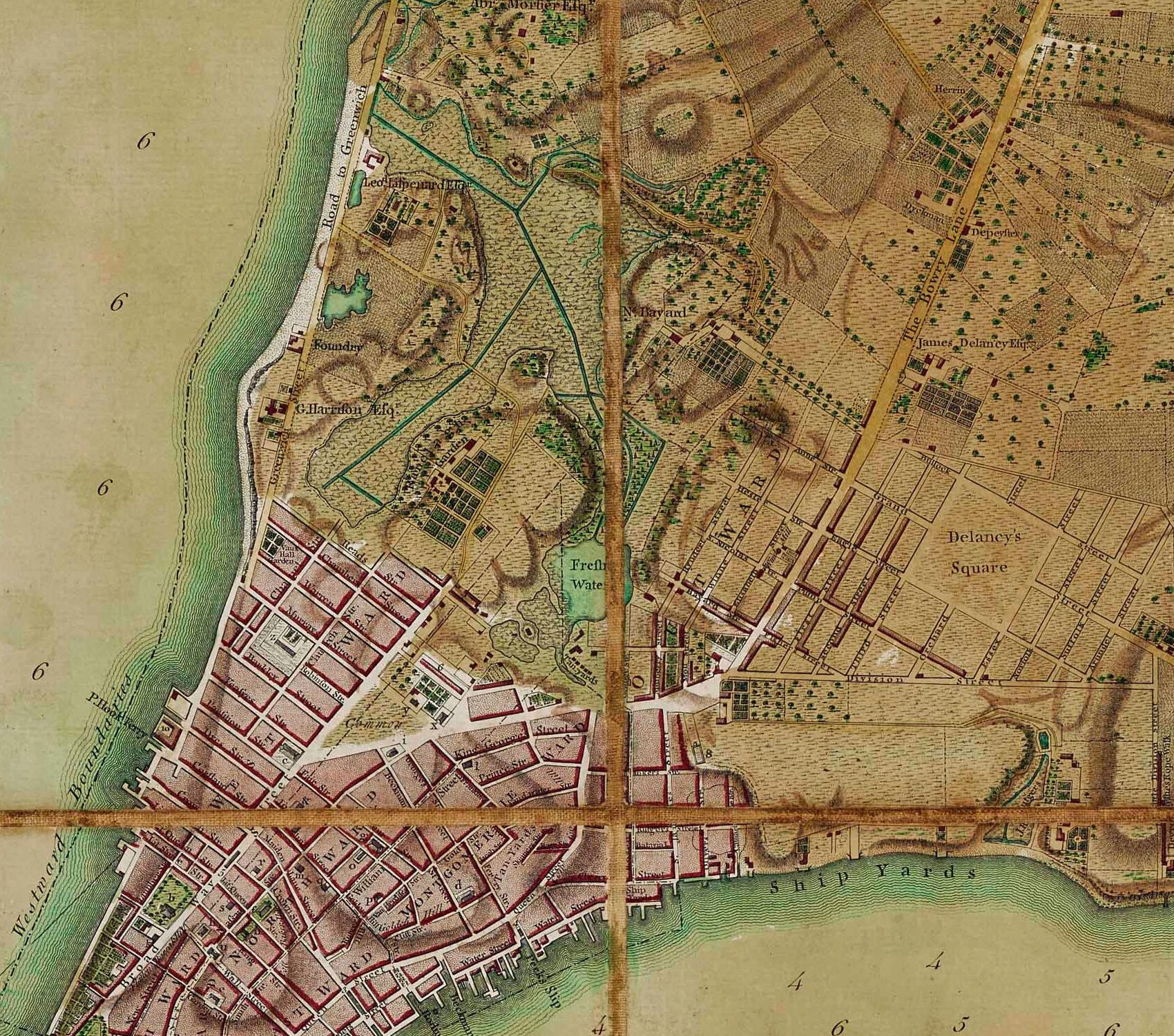 Detail from the Ratzer Plan (surveyed 1766–67, published 1770): the “Fresh Water” (Collect Pond) at center, N. Bayard’s farm above it, and Bowery Lane running northeast at right. Bayard’s Mount rose between the pond and the Bowery. Public domain, via Wikimedia Commons.
The Hill
Bayard’s Mount sat where Mott and Grand Streets meet today. From its summit a viewer could see Collect Pond to the southwest, the orchards and wetlands to the north and west (Lispenard’s Meadow blocked development westward), and travelers on Bowery Lane below to the east. A smaller companion hill, Mount Pleasant, lay just to its east along the Bowery; some period reminiscences treat the two as one ridge.
After the English takeover of New Netherland, most of this land passed to Nicholas Bayard (nephew of Peter Stuyvesant), who built his estate just north of the “small, cone-shaped mount,” and the hill took his name. The grid of the Bayard farm survives today in the street plan of SoHo.
The 1776 Fort
In February 1776, Major General Charles Lee arrived to plan the defense of New York against the expected British invasion. To command the land approach to the city down Bowery Lane, Lee proposed a star-shaped redoubt on Bayard’s Hill, just west of the Bowery — one of three major inland redoubts (with Jones’ Hill near Corlears Hook and Lispenard’s Hill on the Hudson side) to be linked by entrenchments enclosing the southern part of the island.
Construction began in March 1776 with conscripted civilian labor: “One third of the citizens were ordered out to erect new works; they began a fort upon Mr. Bayard’s Mount near the Bowery.” Under General Stirling’s orders, half the city’s male population worked one day, half the next. The work took shape as a large sod-banked heptagonal earthwork — a seven-pointed star — mounting cannon and mortars, with a commanding 360° field of view. (Specific armament counts vary by source; one modern summary credits it with twelve cannon and six mortars, but period returns differ.)
The fort was named Bunker Hill after the 1775 battle outside Boston, and the name stuck to the hill itself — most accounts after 1776 call the place Bunker Hill.
Garrison and notable figures
- Alexander Hamilton — Captain of the New York Provincial Company of Artillery. Hamilton’s company was reportedly stationed at the Bayard’s Hill fort in the summer of 1776, and tradition places him there on the night of August 29–30, 1776, as Washington’s army was ferried across the East River in the retreat from Brooklyn after the Battle of Brooklyn. Accounts of Hamilton’s exact whereabouts that night vary, so TimeWalk treats this as reported/traditional rather than certain. See Alexander Hamilton and Alexander Hamilton at 21 (1776).
- Nathan Hale — the Bowery Boys account notes Hale was stationed at Bunker Hill before his ill-fated intelligence mission. See Nathan Hale.
Abandonment and British occupation
Despite its strength, the fort never fired a shot in battle. When the British landed at Kip’s Bay on September 15, 1776, the American works around the city — Bayard’s Hill included — were abandoned without a fight, and the fort was captured in the British sweep of the city. During the British occupation (1776–1783) the works were a curiosity for British troops; in May 1780 the British incorporated “Bunker Hill” into their own new defense line across the island (work stopped in May 1782). American forces reclaimed the site only at the British evacuation in November 1783, after which the fort was abandoned.
Garrison Life: The Night of August 29, 1776
No surviving document pins down Alexander Hamilton’s exact quarters at the fort — what follows is a reconstruction from standard Continental Army garrison practice in 1776, applied to the specific circumstances of that week. TimeWalk flags it accordingly: plausible reconstruction, not documented fact.
Where he slept. The redoubt had no barracks; its garrison lived in tents pitched inside and immediately behind the earthwork. In quieter weeks an officer might have taken a room in a nearby house — the Bayard farmhouse and the houses along Bowery Lane were minutes away — but August 29 was not a quiet week. Two days after the defeat at the Battle of Brooklyn, the army stood at alarm posts and a nor’easter had been dumping rain for roughly 48 hours. A battery commander that night slept at his post, probably fully dressed, in an officer’s tent. Per Chernow, Hamilton’s company had been quartered in the city near the Common when it was raised in spring 1776; by late August he was living at the works.
What he ate. Company mess: salt pork or fresh beef, ship’s bread or flour baked into firecakes, dried peas, rice, and a rum or spruce-beer ration, cooked over open fires behind the parapet. As captain, Hamilton would have kept a small officers’ mess with his lieutenants, cooked by a soldier-servant. The Bull’s Head Tavern on Bowery Lane — the drovers’ tavern serving the cattle market, a short walk from the fort — was the obvious officer haunt in normal times, but not during that alert week.
Hours at the redoubt. On August 29, effectively all twenty-four. Reveille and the morning gun at dawn (about 5:30), roll call, then wet-weather artillery duty: inspecting the guns, keeping powder dry, tompions in the muzzles, canvas lashed over the embrasures. With a British assault on Manhattan expected at any hour, the garrison stood to at its alarm posts. Through that night the evacuation from Brooklyn ran in secret across the East River — the Manhattan garrisons were deliberately not told — so Hamilton would have been on the parapet or rotating watches with his lieutenants until the famous fog rolled in toward dawn on August 30.
Aaron Burr at the Redoubt (September 15, 1776)
On the night of August 29–30, Aaron Burr — a 20-year-old major and aide-de-camp to General Israel Putnam since June 1776 — was not at this fort: he was with Putnam’s command during the Brooklyn evacuation, credited with helping salvage artillery during the withdrawal.
Burr’s well-documented moment at this fort came two weeks later, on September 15, 1776, during the panic that followed the British landing at Kip’s Bay. As the American line collapsed, part of General Gold Selleck Silliman’s brigade — with Henry Knox among them — fell back to the Bayard’s Mount fort and prepared to make a stand there. Burr rode up and argued the position was hopeless: cut off, short of water and supplies, and certain to be surrounded. He persuaded the troops to abandon the redoubt, then used his knowledge of the island’s back lanes to guide the brigade up the west-side roads to the Bloomingdale Road and north to Harlem, very likely saving it from capture. The episode rests chiefly on accounts collected in Matthew Davis’s Memoirs of Aaron Burr, so details (exact numbers, exact words) should be treated with the usual caution owed to memoir evidence — but the core event is accepted in standard histories of the campaign.
So the same earthwork holds a moment for each of the future duelists: Hamilton on the ramparts through the storm of August 29 (reported/traditional), and Burr talking a brigade out of the fort on September 15 (well documented).
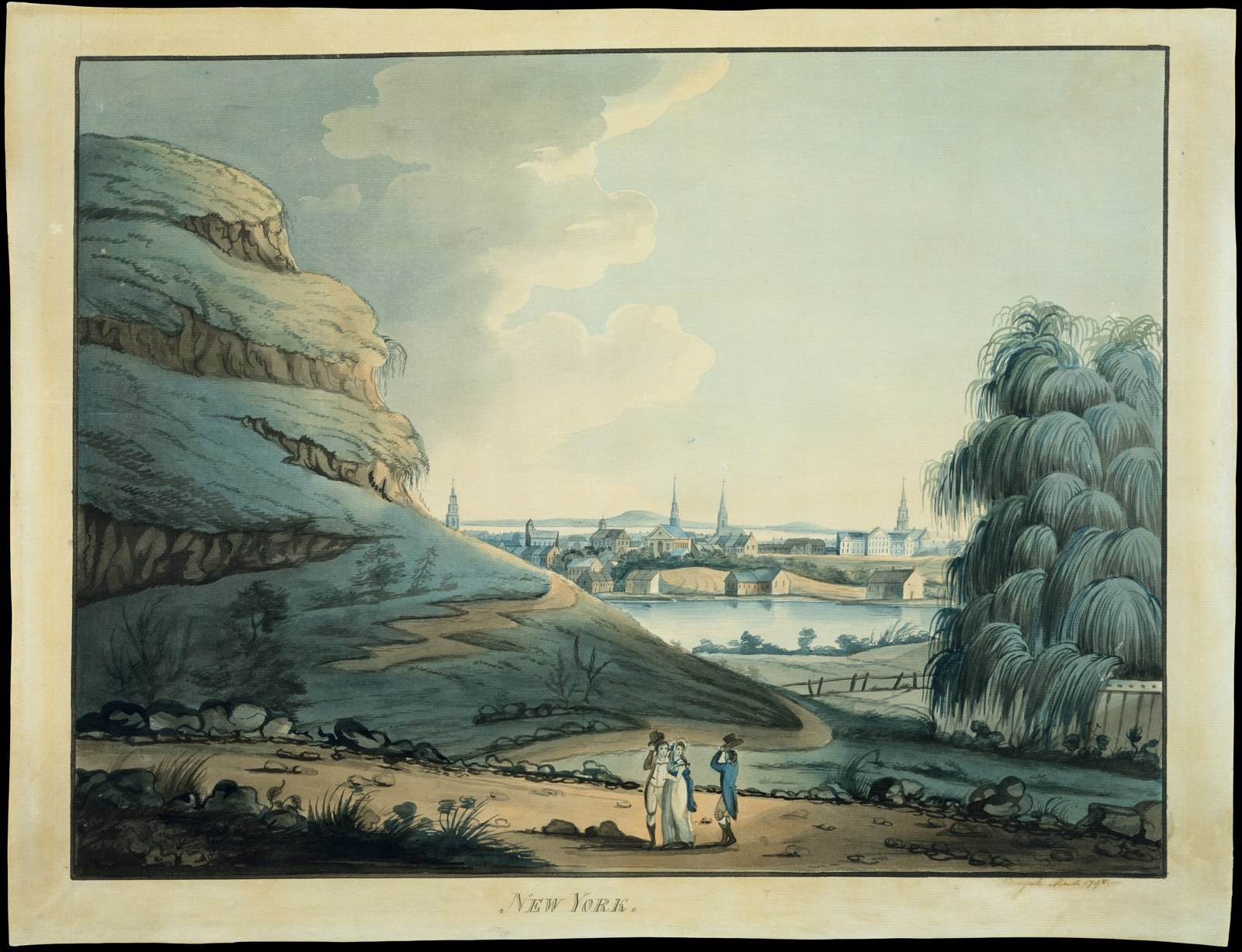 “Collect Pond, New York City” (1798), watercolor attributed to Archibald Robertson, looking south: Bayard’s Mount/Bunker Hill rises at left, Collect Pond at center, the city’s spires beyond. The Metropolitan Museum of Art, Edward W. C. Arnold Collection — public domain.
After the War
The abandoned hilltop became a favorite spot for duels (a fatal French duel was fought there in 1787), public celebrations — in July 1788 a procession celebrating ratification of the Constitution ended at Bunker Hill with “ten enormous tables laden with provisions” and hundreds of pounds of roasted ox — and rowdier pastimes like bull baiting. In 1795 a crowd angry at John Jay’s treaty with Britain burned his portrait in a bonfire here.
Leveling (1802–1811)
As the city pushed north, the Mount was doomed. Beginning in 1802, workmen leveled Bayard’s Mount and Mount Pleasant — in the process relocating the old Bayard family crypt at the base of the hill, which a hermit ragman had famously made his home. The excavated earth went into filling the polluted Collect Pond and its marshes; by about 1811 the pond was gone, the hills were gone, and building lots covered the site. See Manhattan Landfill History.
Timeline
- 1600s (late): Land acquired by Nicholas Bayard; hill becomes “Bayard’s Mount”
- February 1776: Gen. Charles Lee’s defense plan proposes a star-shaped redoubt on Bayard’s Hill
- March 1776: Construction begins with conscripted citizen labor
- Spring–summer 1776: Completed as a heptagonal earthwork, named Fort Bunker Hill / Independent Battery
- August 29–30, 1776: Washington’s night retreat from Brooklyn; Hamilton’s artillery company reportedly at the fort
- September 15, 1776: Americans abandon the city; British capture the works
- May 1780: British rebuild “Bunker Hill” into their occupation defense line
- November 1783: British evacuation; fort abandoned
- 1788: Constitution ratification feast on the hilltop
- 1802–1811: Hill leveled; earth fills Collect Pond
For the UE5 Model
- Georeference: summit ≈ 40.7190 N, 73.9970 W (Grand St between Mott and Mulberry); fort footprint spans roughly the block bounded by today’s Centre, Broome, Mott, and Grand Streets
- Terrain: cone-shaped hill, summit ~110 ft above the period waterline — the dominant landform north of the city in 1776; pair with Collect Pond (immediately southwest) and the lower Mount Pleasant ridge to the east along Bowery Lane
- Structure: seven-pointed star earthwork with sod-banked ramparts, ditch, gun platforms (cannon + mortars), flagstaff; no permanent masonry
- Sightlines: 360° view — key vista south over the city rooftops and harbor, southwest over Collect Pond, east down onto Bowery Lane traffic
- Map evidence: the hill appears on the Ratzer Map (1766) and Montresor 1766 Map; the fort appears on 1776 campaign maps and the British Headquarters Map
- Night of August 29, 1776 scene-dressing: driving northeast rain, no moon, lanterns glowing under canvas, sentries hunched on the parapet, sputtering cook-fires behind the rampart, tents crowded inside and behind the earthwork
Sources
- The Life and Death of Bayard’s Mount, Lower Manhattan’s Missing Mountain — The Bowery Boys — primary narrative backbone: the hill, the fort’s construction, post-war life, and leveling
- Fort Bunker Hill — NY State Military Museum (DMNA) — seven-pointed star design, Centre/Broome/Mott/Grand bounds, British 1780 refortification, 1783 abandonment
- American Revolution Forts & Defenses of New York City — Revolutionary War Journal — Charles Lee’s February 1776 defense plan, citizen-labor construction, abandonment at Kip’s Bay
- Collect Pond — Wikipedia — ~110 ft elevation, leveling and pond fill chronology
- New York Provincial Company of Artillery — Wikipedia — Hamilton’s company and its 1776 New York City posting
- Ron Chernow, Alexander Hamilton (Penguin, 2004) — Hamilton’s company quartered near the Common in spring 1776; his artillery service through the New York campaign
- Matthew L. Davis, Memoirs of Aaron Burr (1836–37) — the September 15, 1776 episode: Burr persuading Silliman’s brigade to abandon the Bayard’s Mount fort and guiding it to Harlem
- Landing at Kip’s Bay — Wikipedia — the September 15 panic and the American withdrawal up the west-side roads
- Ratzer Plan (surveyed 1766–67) — period map evidence for the hill, Bayard farm, and Bowery Lane